What, and where, is the Swilken Burn?
 ‘Burn’ is an Old Scottish word meaning ‘brook’ or ‘stream’. Geographically, the Swilken, or Swilcan, Burn is a watercourse that rises to the northeast of the village of Strathkinness, three miles west of St. Andrews, and flows 2¾ miles into St. Andrews Bay, on the eastern coastline of North East Fife. From a sporting perspective, the Swilken Burn is noteworthy because, after flowing through the North Haugh area, it turns northeast and meanders across the Old Course at the Royal & Ancient Golf Club of St. Andrews.
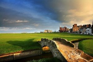
Indeed, the route of the Swilken Burn was fixed for the first time in 1834, with the addition of brick retaining wall, such that, nowadays, it fronts the first green and continues across the eighteenth fairway. Carrying the burn on the exposed, but otherwise gentle, opening hole – fittingly, named ‘Burn’ – presents a challenge and, while the hazard is not really in play on the final hole, it does, at least, present a photogaphic opportunity, courtesy of the Swilken Bridge.
Formerly known as the ‘Golfers’ Bridge’, the Swilken Bridge is a small, unprepossessing stone arch, dating from the Middle Ages, which has, nonetheless, become one of the most landmarks in the world of golf. St. Andrews, known as the ‘home of golf’, has played host to the Open Championship 29 times and is scheduled to do so again in 2022. It is customary for previous champions, including, in recent years, Jack Nicklaus and Tom Watson, to bid farewell to the gallery, and the Championship, from atop the Swilken Bridge.